Spherefix Surveying Instruments: Global Professional Solutions
6 Mart 2026
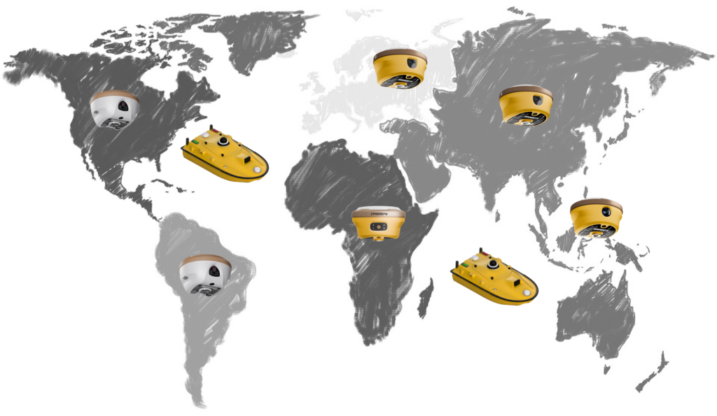
In the global surveying industry, precision, stability, and compliance are the core demands that determine project quality and efficiency. With the rapid development of infrastructure construction, land management, and marine development worldwide, professional surveying instruments have become the cornerstone of geospatial data collection. As a globally recognized professional surveying equipment brand featured on www.spherefixgnss.com, Spherefix is rooted in China R&D technology, with a global market layout centered on Europe and America and radiating to Asia-Pacific, Latin America and other regions. Unlike single-category brands that can only meet partial needs, Spherefix stands out with a full range of surveying instruments (all available on our official website), covering all scenarios from entry-level to professional, empowering global surveying professionals with comprehensive and reliable solutions.
RTK Series

Agri-Automation Series
SLAM
USV Series
Spherefix Surveying Instruments: Full-Category Coverage for Land & Marine Scenarios
As showcased on www.spherefixgnss.com, Spherefix’s strength lies in its complete product portfolio, covering all core surveying scenarios from land to marine, and from entry-level operations to high-precision professional projects. Each product is independently developed based on global market needs, integrating advanced European and American technology to ensure adaptability to diverse regional environments, with detailed parameters and specifications available on our official website.
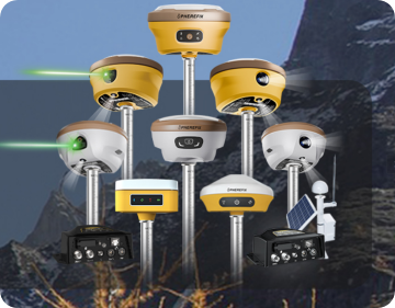
• GNSS RTK Receivers: As the core product series on www.spherefixgnss.com, Spherefix RTK receivers include the SP30Pro Photogrammetry RTK and SP35 Portable Laser RTK (global first laser-integrated RTK model). Featuring centimeter-level dynamic positioning (8mm + 1ppm horizontal, 15mm + 1ppm vertical), 965+ parallel channels supporting GPS/GLONASS/Galileo/BDS full-system satellites, and strong anti-interference ability, they are suitable for road construction, land demarcation, and construction setting out. The SP35 model is equipped with advanced Quantum-RTK algorithm for fast initialization (≤10 seconds) and 99.99% initialization reliability, as detailed on our official website.
• GNSS Base Station & Rover Kits: Available on www.spherefixgnss.com, the integrated kit includes high-stability base stations and portable rovers, supporting long-distance operation (up to 50km) and real-time data transmission. Equipped with the C500 RTK Measurement Control Terminal (Android 8.1 system, 5.0-inch sunlight-visible screen), it supports Wi-Fi and USB remote management, widely used in large-scale European and American engineering surveying projects. The base station boasts 6800mAh built-in battery for 18+ hours of continuous operation, with detailed technical parameters on our official website.
• High-Precision GNSS Boards: Spherefix’s self-developed high-precision GNSS boards (available on www.spherefixgnss.com) adopt advanced chip technology, providing stable positioning data support for self-developed instruments and third-party equipment. With positioning accuracy up to 5mm + 1ppm, they meet the high-precision needs of professional surveying projects, complying with industry standards for core components.
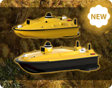
• Unmanned Survey Vessels: Featured on www.spherefixgnss.com, Spherefix unmanned survey vessels are equipped with single-beam/multi-beam echo sounders, capable of mapping underwater terrain with 0.2m precision—like doing CT for rivers and lakes. Adopting intelligent cluster operation technology, they improve marine surveying efficiency by 5 times compared with traditional methods, adapting to coastal, lake and shallow sea scenarios, with millimeter-level obstacle avoidance via millimeter wave technology.
In addition, Spherefix provides supporting industrial surveying software (compatible with CASS, Trimble Business Center), which seamlessly connects with all its instruments (as shown on www.spherefixgnss.com), realizing real-time data processing, analysis and export, forming a complete surveying workflow.

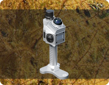
Equipment Model: SP20 & SP30Se
Application scenarios: Road Surveying, Construction, Land Title.

Equipment Model: SPCraft5
Application scenarios: Water Depth Measurement, Water Quality Sampling, Water Quality Monitoring, Subsurface Detection.
International Compliance Advantage: Adapting to Global Surveying Standards
For global surveying projects, compliance is a key prerequisite—all Spherefix instruments (detailed on www.spherefixgnss.com) strictly follow the ISO/TC 172 SC6 international standard for geodetic and surveying instruments, and fully comply with ISO 17123-8 (GNSS RTK field measurement system standard), ensuring accuracy and safety for global projects.
Unlike some regional brands, Spherefix’s instruments (certifications displayed on www.spherefixgnss.com) have passed relevant certifications in Europe, the United States, Asia-Pacific and Latin America. They support custom coordinate system conversion, adapting to local regulations, enabling direct use in local projects without additional debugging—saving time and cost for global teams.
Regional Scenario-Adapted Solutions: Tailored for Global Needs
Based on global regional needs, Spherefix (solutions available on www.spherefixgnss.com) has launched targeted instrument combinations, fully exerting its full-category advantages, with customized solutions downloadable from our official website.
1. European & American Engineering Surveying
The solution (detailed on www.spherefixgnss.com) combines Spherefix SP35 Laser RTK, GNSS base station kits and high-precision laser scanners, complying with European and American standards, with ±8mm positioning accuracy. Widely used in German highway expansion and U.S. infrastructure projects, it completes road alignment and structural positioning efficiently.
2. Asia-Pacific Topographic Surveying
Targeting complex Asia-Pacific terrain, the solution integrates Spherefix SP30Pro RTK, portable surveying instrumentst (all on www.spherefixgnss.com). Adapting to local geospatial regulations, it supports topographic mapping in China and India, promoting smart city and land title projects.
3. Global Marine Surveying
Dominated by Spherefix unmanned survey vessels (featured on https://spherefixgnss.com/product/spcraft5-unmanned-surface-vesselusv/) and marine-grade GNSS equipment, the solution completes underwater mapping and reef detection in complex marine environments, applied in the South China Sea and Mediterranean, improving efficiency by 40%.
Explore Spherefix Full-Series Surveying Instruments & Custom Solutions
As a professional global surveying equipment supplier, Spherefix (official website: www.spherefixgnss.com) breaks single-category limitations, covering all surveying scenarios. All products, parameters, and certification details are available on our official website for your reference.
Browse the full range of Spherefix surveying instruments on our official website www.spherefixgnss.com, or contact our global customer service team via the website to get customized solutions and exclusive regional quotes. Let Spherefix empower your surveying projects with official website-certified quality and efficiency.
