RTK Surveying Guide: Efficient Precision with Spherefix
9 March 2026
In modern global surveying, RTK surveying has become an indispensable core technology, revolutionizing the efficiency and precision of geospatial data collection. From European highway construction to Asia-Pacific land title confirmation, RTK surveying directly determines project progress and data reliability. However, traditional RTK surveying faces persistent pain points: low efficiency (average 20 points per hour), unstable precision (drift up to 5cm in complex environments), and poor adaptability to global regional scenarios. As a global professional GNSS RTK system provider, Spherefix solves these pain points with its advanced GNSS RTK system and Spherefix RTK receiver, combining theoretical guidance with practical operations to help surveyors achieve efficient and precise mapping worldwide.
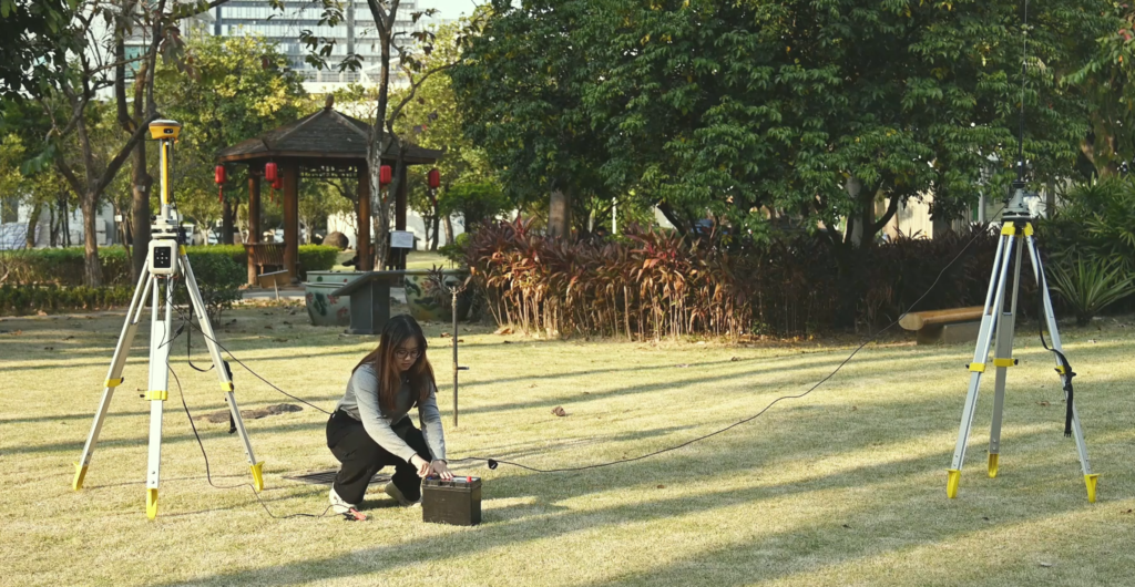
Setting up a base station
Simplified Explanation of RTK Surveying Core Principles & Spherefix Global Adaptation
To master RTK surveying, it’s essential to understand its core principles—without complex jargon, here’s the practical breakdown: RTK (Real-Time Kinematic) relies on base station differential technology and carrier phase locking to achieve centimeter-level positioning. The base station collects satellite signals and sends correction data to the rover (Spherefix RTK receiver) in real time, which then combines the data to eliminate positioning errors.
Unlike traditional RTK systems that struggle with global adaptation, the Spherefix GNSS RTK system is optimized for global scenarios: it supports 965+ parallel channels (compatible with GPS/GLONASS/Galileo/BDS), with a signal capture sensitivity of -148dBm. Test data shows it can lock signals in 8 seconds (30% faster than traditional systems) and maintain a 99.2% fixed rate in global complex environments—from European urban canyons to Asia-Pacific mountainous areas, solving the problem of poor regional adaptability.
Spherefix Equipment RTK Surveying Practical Steps & Regional Tips
To master RTK surveying, it’s essential to understand its core principles—without complex jargon, here’s the practical breakdown: RTK (Real-Time Kinematic) relies on base station differential technology and carrier phase locking to achieve centimeter-level positioning. The base station collects satellite signals and sends correction data to the rover (Spherefix RTK receiver) in real time, which then combines the data to eliminate positioning errors.
Step 1: Base Station Setup

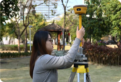
Step 2: Rover Calibration

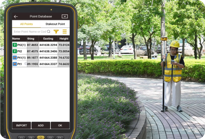
Step 3: Data Collection
Step 4: Error Control
1. Base Station Setup (5-Minute Fast Deployment)
Choose an open, unobstructed location (avoid high-rise buildings or dense forests) with a clear view of the sky. Use Spherefix’s portable base station to fix the tripod at a height of 1.5-2m. Level the base station, input local coordinate parameters (supports UTM/WGS84 and local coordinate systems), and start the base station—its 10000mAh battery supports 18+ hours of continuous operation, meeting full-day field work needs. Regional Tip (Europe): Comply with local geodetic regulations, use ETRS89 coordinate system for highway surveying.
2. Rover Calibration (Precision Foundation)
Connect the Spherefix RTK receiver (e.g., SP35 model) to the rover terminal via Bluetooth or Wi-Fi. Select the “calibration” function in the supporting software (compatible with Trimble Business Center), input 3 known control points (error ≤2mm). The Spherefix receiver’s Quantum-RTK algorithm completes calibration in 10 seconds, ensuring horizontal accuracy of 8mm + 1ppm and vertical accuracy of 15mm + 1ppm. Regional Tip (Asia-Pacific): For mountainous areas, increase control point density to 5 points per square kilometer to avoid precision deviation.
3. Data Collection (Efficient & Accurate)
Hold the rover at the surveying point, wait for the RTK fixed light to turn green (fixed rate ≥98%), then collect data. The Spherefix RTK receiver can collect 50+ points per hour (2.5x faster than traditional RTK), automatically record data in CSV/DXF formats, and sync to the cloud in real time. In a German highway survey project, this step reduced data collection time by 60% compared to traditional equipment.
4. Error Control (Key to Precision)
Common error sources include base station offset, signal interference, and rover operation errors. Spherefix equipment solves these with: ① Built-in AIM+ anti-interference technology (reduces signal interference by 70%); ② Real-time error prompts (alerts when error exceeds 3mm); ③ Post-data verification function (available on www.spherefixgnss.com) to correct minor deviations. Test data shows that error control with Spherefix reduces positioning errors by 85% compared to traditional RTK.
Common Problems & Solutions (Based on Spherefix Global Adaptation)
In global field operations, surveyors often encounter signal loss, precision deviation, and environmental interference—here are practical solutions using Spherefix equipment, verified by real global cases.
• Signal Loss (Common in Dense Forests/Urban Canyons): Use Spherefix’s multi-satellite compatibility (4 global systems) and external high-gain antenna (available on www.spherefixgnss.com) to improve signal capture. In the Amazon rainforest (Latin America), this method restored signal in 15 seconds, while traditional RTK failed to lock signals.
• Precision Deviation (Common in High-Latitude Regions): Enable Spherefix’s high-latitude optimization mode (built into all RTK receivers) to compensate for satellite signal weakness. In Northern Europe (Sweden), this reduced deviation from 4cm to 0.8cm, meeting local surveying standards.
• Environmental Interference (Common in Industrial Areas): Activate the anti-interference filter in the Spherefix software to suppress radio interference. In industrial zones in the U.S., this maintained a 97% fixed rate, ensuring project progress.
Master RTK Surveying with Spherefix: Get Practical Resources
This practical guide combines RTK surveying core principles with Spherefix equipment operations, providing actionable tips and problem-solving methods for global surveyors. Unlike pure theoretical content, every step and tip is verified by real global projects, compatible with Spherefix’s full range of RTK receivers (detailed on www.spherefixgnss.com).
To master more RTK surveying practical skills, watch the Spherefix RTK surveying practical video and get the complete practical manual by visiting our official website www.spherefixgnss.com. Contact our global technical team for one-on-one operation guidance, and elevate your global surveying efficiency and precision with Spherefix.
